
Bayreuth
95447 Bayreuth, Deutschland
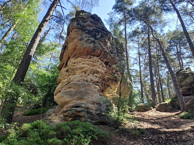
Buchstein Bayreuth | Hiking & Geotope
The Buchstein is not a classic event venue at the edge of Bayreuth, but a natural destination that is primarily associated with hiking, access, geotope, rock formations, and family outings in search queries. This is precisely its strength: Instead of grandstands, tickets, or stage plans, the Buchstein offers forest paths, sandstone rocks, small caves, and a quiet, picturesque setting for a break in nature. The official Natura 2000 description classifies the area as an approximately 13-hectare large FFH area, mentions the hilltop at 411 m above sea level, and describes spectacular sandstone rock towers with sparse forest cover of birch and pine. The Bayreuth tourism website locates the excursion destination on the outskirts near the agricultural training institutes, accessible via a small pond, a forest house, and steadily rising access paths through mixed forest. ([lfu.bayern.de](https://www.lfu.bayern.de/natur/natura2000_managementplaene/6020_6946/doc/6035_302/texte/de6035302_t_fg_ffin_nfin.pdf))
For SEO planning, the topics of access, hiking trail, geotope, rocks, and family-friendliness are particularly relevant for this location. Official sources clearly show that the Buchstein is not intended as an event location but as a landscape-shaped excursion destination with protective status and natural scientific value. At the same time, its location on the outskirts makes it easy to integrate into a visit to Bayreuth: Those traveling from the city center reach a destination that quickly takes on the character of a true forest and rock landscape. This creates a mix of urban proximity and nature experience that makes the Buchstein particularly attractive for seekers. ([bayreuth-tourismus.de](https://www.bayreuth-tourismus.de/wander-geheimtipp-buchstein/))
Access to Buchstein in Bayreuth
The best documented orientation for accessing the Buchstein begins at the former Altstadt train station. The Bayreuth tourism description explicitly states that this starting point can be reached on foot or by public transport. From there, the route heads southwest out of the urban area, first over open meadows, then to the forest edge, and finally up steeper access paths to the Buchstein. This sequence already makes the journey part of the experience, as the transition from city, meadow, and forest is particularly pleasant for a short outing and is clearly described. Those who do not want to start directly in the vicinity of the rocks but are looking for a clean access point with good orientation have the most reliable route with this official starting point. ([bayreuth-tourismus.de](https://www.bayreuth-tourismus.de/von-imposanten-gesteinsformationen-und-faszinierenden-panoramen/))
It is important to make an honest classification: The Buchstein is not a location with a classic visitor reception, no hall, and no area with a fixed hall plan. Public information instead speaks of a hiking destination at the city gates. Therefore, terms like parking garage, ticket sales, or event access are not suitable for the Buchstein itself. What the sources clearly indicate is rather the practical accessibility via footpaths and public transport, as well as the connection to existing city and nature paths. For visitors who like to plan their tour well, this is ideal because the path is oriented not towards a closed facility but towards the topography. Here, the path is thus part of the attraction. ([bayreuth-tourismus.de](https://www.bayreuth-tourismus.de/von-imposanten-gesteinsformationen-und-faszinierenden-panoramen/))
Hiking at Buchstein: Forest paths, rocks, and perspectives
The hike at Buchstein thrives on a simple yet effective contrast: The path begins at the bottom with a small pond and a forest house, then access paths steadily rise through shady mixed forest until the striking rock formations appear at the top. The Bayreuth tourism description emphasizes that one can first take a deep breath at the top, take a break on a bench, and enjoy a leisurely snack. Additionally, the chirping of birds and the rustling of the forest give the Buchstein tour a calm, decelerated pace. This gradual approach to the rocks makes the place so memorable. Instead of an immediate attraction, the natural image unfolds step by step, and in the end, large and small rock fragments stand in the middle of the forest, allowing for new perspectives. ([bayreuth-tourismus.de](https://www.bayreuth-tourismus.de/wander-geheimtipp-buchstein/))
The second official description from Bayreuth tourism also confirms this image and adds another important aspect: Families with children should plan a bit more time because the Buchstein is particularly well-suited for climbing and hiding in the surrounding area. This is a strong signal for all those looking for a nature-oriented but not overly long outing. The uphill path is not spectacularly difficult but clear enough to create a sense of arrival. After that, there is often a pleasant return path downhill that feels easier and rounds off the tour. Therefore, those planning the Buchstein as a hiking destination will not receive an alpine extreme route but a compact, characterful nature hike with rocks, forest, and short experiences in a confined space. ([bayreuth-tourismus.de](https://www.bayreuth-tourismus.de/wander-geheimtipp-buchstein/))
Rhaetian sandstone, caves, and geotope protection
Geologically, the Buchstein is particularly exciting because the rock towers and blocks are not only visually striking but also scientifically significant. The management plan for the FFH area describes the site as a location of spectacular sandstone rock towers, where steps, overhangs, fissures, and caves occur. A rich cryptogam flora, including luminescent moss and a rare hair lichen, as well as numerous insects and spiders are also mentioned. The legal framework is particularly important: Open rock formations like the rock towers at Buchstein are protected as biotopes under the Bavarian Nature Conservation Act, and the Buchstein itself is protected as a geotope due to its weathering forms; the geotope register cites the number 462R001. ([lfu.bayern.de](https://www.lfu.bayern.de/natur/natura2000_managementplaene/6020_6946/doc/6035_302/texte/de6035302_t_fg_ffin_nfin.pdf))
Additionally, the Buchstein plays a connecting role in the Natura 2000 network. The management plan mentions the transition to the moist valley floors of the Main and Mistelbach as well as to the nearby Rhaetian gorges near Bayreuth. While this may not be a tourist buzzword for visitors, it is very valuable for the classification of the landscape: The Buchstein is not isolated but is part of a larger ecological context. The caves are also noteworthy. The plan lists the habitat type of non-touristically developed caves; three larger caves and numerous semi-caves are described there, with varying depths, crevices, side passages, and partly moist-cool areas. This makes the Buchstein a place where nature, geology, and nature conservation meet very directly. ([lfu.bayern.de](https://www.lfu.bayern.de/natur/natura2000_managementplaene/6020_6946/doc/6035_302/texte/de6035302_t_fg_ffin_nfin.pdf))
History and legend of the name Buchstein
The name Buchstein is closely linked to a local legend that the Bayreuth tourism site explicitly mentions. According to this, during the Thirty Years' War, books from the city archives of Bayreuth were supposedly stored in the rock crevices, from which the name is said to derive. This narrative is particularly appealing to visitors because it gives the rock formation a historical notion and enriches the place beyond its mere landscape effect. Especially at nature destinations with prominent rocks, such legends create an additional layer: one does not only see sandstone blocks but also thinks of protection, hiding, and history. This interplay of landscape and narrative makes the Buchstein so interesting for content that goes beyond simple route descriptions. ([bayreuth-tourismus.de](https://www.bayreuth-tourismus.de/wander-geheimtipp-buchstein/))
However, it is important to exercise linguistic caution, as the official formulation also suggests: It does not state that the story is definitively proven but that it is told according to legend. For a clean SEO description, this is ideal because it allows for an atmospheric approach combined with factual restraint. The Buchstein thus does not become an artificially embellished myth but a place where nature and local memory coexist side by side. Therefore, those who walk through the mixed forest to the rocks today not only get a hike but also a small cultural narrative space along the way. And this added value explains why the name Buchstein generates more attention in Bayreuth than many other forest destinations near the city. ([bayreuth-tourismus.de](https://www.bayreuth-tourismus.de/wander-geheimtipp-buchstein/))
Family outing, nature observation, and respectful interaction
For families, the Buchstein is particularly interesting because the official texts not only speak of a rocky landscape but quite specifically about climbing and hide-and-seek games. This is rarely so clearly formulated in a tourism description and immediately makes it understandable how the place can be used: not as a strictly staged park but as a movement-friendly natural backdrop. At the top, there is a bench for breaks, at the bottom, cows graze at the starting point, and overall, the place conveys a relaxed mix of movement and observation. Therefore, those traveling with children will find here not a crowded excursion destination but a manageable, nature-friendly environment with enough stimuli to hold their attention. ([bayreuth-tourismus.de](https://www.bayreuth-tourismus.de/wander-geheimtipp-buchstein/))
The further official hiking description also provides beautiful nature details. From the Buchstein, the path leads through shady forest landscapes along sand pits towards Sophienberg; along the way, hikers pass fish ponds described as a species-rich biotope. There, with a bit of luck, lizards, grass snakes, and kingfishers can be observed. This is particularly attractive for nature lovers because the Buchstein thus becomes part of a varied route that connects rock, forest, water, and open landscape. At the same time, one should take the protective character of the area seriously: Open rock formations are protected, and the sensitive cave and rock habitats also deserve respectful interaction. Those who stay on the paths and do not misunderstand the landscape as a climbing park help ensure that this special place is preserved in the long term. ([lfu.bayern.de](https://www.lfu.bayern.de/natur/natura2000_managementplaene/6020_6946/doc/6035_302/texte/de6035302_t_fg_ffin_nfin.pdf))
Practical planning and search intentions around Buchstein
Those searching for Buchstein will easily encounter different meanings of the name online. This is important for planning because in Bayreuth there is not only the excursion destination Buchstein but also other places with the same name, such as the composting facility Am Buchstein and the parish Am Buchstein. This is why a clear distinction is helpful: For hikers and excursionists, Buchstein refers to the rock and forest landscape on the outskirts of the city, not a technical facility or a church location. The official Bayreuth pages confirm this name similarity and simultaneously show how strongly the term is anchored in the local cityscape. ([bayreuth.de](https://www.bayreuth.de/kompostierungsanlage-am-22-und-23-oktober-geschlossen/))
For the actual planning, it is therefore most important to think of the tour as a nature outing. The best official starting information remains the former Altstadt train station; additionally, the character as a hiking destination at the city gates and the connection to forest paths, sandstone formations, and the subsequent panorama towards Sophienberg are important. The Bayreuth tourism site also mentions the Buchstein as a destination for winter walks with beautiful forest paths and striking sandstone rock formations, showing that the place works not only in one season. Therefore, if one wants to market the Buchstein in Bayreuth sensibly or present it on a website, one should prioritize the search terms hiking, geotope, rocks, family, access, and nature experience. This intention best reflects the information situation and simultaneously avoids distraction from similarly named but content-wise entirely different places. ([bayreuth-tourismus.de](https://www.bayreuth-tourismus.de/von-imposanten-gesteinsformationen-und-faszinierenden-panoramen/))
Sources:
- Bayreuth Tourism - Hiking Secret Tip Buchstein ([bayreuth-tourismus.de](https://www.bayreuth-tourismus.de/wander-geheimtipp-buchstein/))
- Bavarian State Office for the Environment - Natura 2000 Management Plan Buchstein ([lfu.bayern.de](https://www.lfu.bayern.de/natur/natura2000_managementplaene/6020_6946/doc/6035_302/texte/de6035302_t_fg_ffin_nfin.pdf))
- Bayreuth Tourism - From Impressive Rock Formations and Fascinating Panoramas ([bayreuth-tourismus.de](https://www.bayreuth-tourismus.de/von-imposanten-gesteinsformationen-und-faszinierenden-panoramen/))
- City of Bayreuth - Composting Facility Am Buchstein Poorly Accessible During Road Works ([bayreuth.de](https://www.bayreuth.de/kompostieranlage-am-buchstein-waehrend-strassenarbeiten-schlecht-erreichbar/))
Show moreShow less
Buchstein Bayreuth | Hiking & Geotope
The Buchstein is not a classic event venue at the edge of Bayreuth, but a natural destination that is primarily associated with hiking, access, geotope, rock formations, and family outings in search queries. This is precisely its strength: Instead of grandstands, tickets, or stage plans, the Buchstein offers forest paths, sandstone rocks, small caves, and a quiet, picturesque setting for a break in nature. The official Natura 2000 description classifies the area as an approximately 13-hectare large FFH area, mentions the hilltop at 411 m above sea level, and describes spectacular sandstone rock towers with sparse forest cover of birch and pine. The Bayreuth tourism website locates the excursion destination on the outskirts near the agricultural training institutes, accessible via a small pond, a forest house, and steadily rising access paths through mixed forest. ([lfu.bayern.de](https://www.lfu.bayern.de/natur/natura2000_managementplaene/6020_6946/doc/6035_302/texte/de6035302_t_fg_ffin_nfin.pdf))
For SEO planning, the topics of access, hiking trail, geotope, rocks, and family-friendliness are particularly relevant for this location. Official sources clearly show that the Buchstein is not intended as an event location but as a landscape-shaped excursion destination with protective status and natural scientific value. At the same time, its location on the outskirts makes it easy to integrate into a visit to Bayreuth: Those traveling from the city center reach a destination that quickly takes on the character of a true forest and rock landscape. This creates a mix of urban proximity and nature experience that makes the Buchstein particularly attractive for seekers. ([bayreuth-tourismus.de](https://www.bayreuth-tourismus.de/wander-geheimtipp-buchstein/))
Access to Buchstein in Bayreuth
The best documented orientation for accessing the Buchstein begins at the former Altstadt train station. The Bayreuth tourism description explicitly states that this starting point can be reached on foot or by public transport. From there, the route heads southwest out of the urban area, first over open meadows, then to the forest edge, and finally up steeper access paths to the Buchstein. This sequence already makes the journey part of the experience, as the transition from city, meadow, and forest is particularly pleasant for a short outing and is clearly described. Those who do not want to start directly in the vicinity of the rocks but are looking for a clean access point with good orientation have the most reliable route with this official starting point. ([bayreuth-tourismus.de](https://www.bayreuth-tourismus.de/von-imposanten-gesteinsformationen-und-faszinierenden-panoramen/))
It is important to make an honest classification: The Buchstein is not a location with a classic visitor reception, no hall, and no area with a fixed hall plan. Public information instead speaks of a hiking destination at the city gates. Therefore, terms like parking garage, ticket sales, or event access are not suitable for the Buchstein itself. What the sources clearly indicate is rather the practical accessibility via footpaths and public transport, as well as the connection to existing city and nature paths. For visitors who like to plan their tour well, this is ideal because the path is oriented not towards a closed facility but towards the topography. Here, the path is thus part of the attraction. ([bayreuth-tourismus.de](https://www.bayreuth-tourismus.de/von-imposanten-gesteinsformationen-und-faszinierenden-panoramen/))
Hiking at Buchstein: Forest paths, rocks, and perspectives
The hike at Buchstein thrives on a simple yet effective contrast: The path begins at the bottom with a small pond and a forest house, then access paths steadily rise through shady mixed forest until the striking rock formations appear at the top. The Bayreuth tourism description emphasizes that one can first take a deep breath at the top, take a break on a bench, and enjoy a leisurely snack. Additionally, the chirping of birds and the rustling of the forest give the Buchstein tour a calm, decelerated pace. This gradual approach to the rocks makes the place so memorable. Instead of an immediate attraction, the natural image unfolds step by step, and in the end, large and small rock fragments stand in the middle of the forest, allowing for new perspectives. ([bayreuth-tourismus.de](https://www.bayreuth-tourismus.de/wander-geheimtipp-buchstein/))
The second official description from Bayreuth tourism also confirms this image and adds another important aspect: Families with children should plan a bit more time because the Buchstein is particularly well-suited for climbing and hiding in the surrounding area. This is a strong signal for all those looking for a nature-oriented but not overly long outing. The uphill path is not spectacularly difficult but clear enough to create a sense of arrival. After that, there is often a pleasant return path downhill that feels easier and rounds off the tour. Therefore, those planning the Buchstein as a hiking destination will not receive an alpine extreme route but a compact, characterful nature hike with rocks, forest, and short experiences in a confined space. ([bayreuth-tourismus.de](https://www.bayreuth-tourismus.de/wander-geheimtipp-buchstein/))
Rhaetian sandstone, caves, and geotope protection
Geologically, the Buchstein is particularly exciting because the rock towers and blocks are not only visually striking but also scientifically significant. The management plan for the FFH area describes the site as a location of spectacular sandstone rock towers, where steps, overhangs, fissures, and caves occur. A rich cryptogam flora, including luminescent moss and a rare hair lichen, as well as numerous insects and spiders are also mentioned. The legal framework is particularly important: Open rock formations like the rock towers at Buchstein are protected as biotopes under the Bavarian Nature Conservation Act, and the Buchstein itself is protected as a geotope due to its weathering forms; the geotope register cites the number 462R001. ([lfu.bayern.de](https://www.lfu.bayern.de/natur/natura2000_managementplaene/6020_6946/doc/6035_302/texte/de6035302_t_fg_ffin_nfin.pdf))
Additionally, the Buchstein plays a connecting role in the Natura 2000 network. The management plan mentions the transition to the moist valley floors of the Main and Mistelbach as well as to the nearby Rhaetian gorges near Bayreuth. While this may not be a tourist buzzword for visitors, it is very valuable for the classification of the landscape: The Buchstein is not isolated but is part of a larger ecological context. The caves are also noteworthy. The plan lists the habitat type of non-touristically developed caves; three larger caves and numerous semi-caves are described there, with varying depths, crevices, side passages, and partly moist-cool areas. This makes the Buchstein a place where nature, geology, and nature conservation meet very directly. ([lfu.bayern.de](https://www.lfu.bayern.de/natur/natura2000_managementplaene/6020_6946/doc/6035_302/texte/de6035302_t_fg_ffin_nfin.pdf))
History and legend of the name Buchstein
The name Buchstein is closely linked to a local legend that the Bayreuth tourism site explicitly mentions. According to this, during the Thirty Years' War, books from the city archives of Bayreuth were supposedly stored in the rock crevices, from which the name is said to derive. This narrative is particularly appealing to visitors because it gives the rock formation a historical notion and enriches the place beyond its mere landscape effect. Especially at nature destinations with prominent rocks, such legends create an additional layer: one does not only see sandstone blocks but also thinks of protection, hiding, and history. This interplay of landscape and narrative makes the Buchstein so interesting for content that goes beyond simple route descriptions. ([bayreuth-tourismus.de](https://www.bayreuth-tourismus.de/wander-geheimtipp-buchstein/))
However, it is important to exercise linguistic caution, as the official formulation also suggests: It does not state that the story is definitively proven but that it is told according to legend. For a clean SEO description, this is ideal because it allows for an atmospheric approach combined with factual restraint. The Buchstein thus does not become an artificially embellished myth but a place where nature and local memory coexist side by side. Therefore, those who walk through the mixed forest to the rocks today not only get a hike but also a small cultural narrative space along the way. And this added value explains why the name Buchstein generates more attention in Bayreuth than many other forest destinations near the city. ([bayreuth-tourismus.de](https://www.bayreuth-tourismus.de/wander-geheimtipp-buchstein/))
Family outing, nature observation, and respectful interaction
For families, the Buchstein is particularly interesting because the official texts not only speak of a rocky landscape but quite specifically about climbing and hide-and-seek games. This is rarely so clearly formulated in a tourism description and immediately makes it understandable how the place can be used: not as a strictly staged park but as a movement-friendly natural backdrop. At the top, there is a bench for breaks, at the bottom, cows graze at the starting point, and overall, the place conveys a relaxed mix of movement and observation. Therefore, those traveling with children will find here not a crowded excursion destination but a manageable, nature-friendly environment with enough stimuli to hold their attention. ([bayreuth-tourismus.de](https://www.bayreuth-tourismus.de/wander-geheimtipp-buchstein/))
The further official hiking description also provides beautiful nature details. From the Buchstein, the path leads through shady forest landscapes along sand pits towards Sophienberg; along the way, hikers pass fish ponds described as a species-rich biotope. There, with a bit of luck, lizards, grass snakes, and kingfishers can be observed. This is particularly attractive for nature lovers because the Buchstein thus becomes part of a varied route that connects rock, forest, water, and open landscape. At the same time, one should take the protective character of the area seriously: Open rock formations are protected, and the sensitive cave and rock habitats also deserve respectful interaction. Those who stay on the paths and do not misunderstand the landscape as a climbing park help ensure that this special place is preserved in the long term. ([lfu.bayern.de](https://www.lfu.bayern.de/natur/natura2000_managementplaene/6020_6946/doc/6035_302/texte/de6035302_t_fg_ffin_nfin.pdf))
Practical planning and search intentions around Buchstein
Those searching for Buchstein will easily encounter different meanings of the name online. This is important for planning because in Bayreuth there is not only the excursion destination Buchstein but also other places with the same name, such as the composting facility Am Buchstein and the parish Am Buchstein. This is why a clear distinction is helpful: For hikers and excursionists, Buchstein refers to the rock and forest landscape on the outskirts of the city, not a technical facility or a church location. The official Bayreuth pages confirm this name similarity and simultaneously show how strongly the term is anchored in the local cityscape. ([bayreuth.de](https://www.bayreuth.de/kompostierungsanlage-am-22-und-23-oktober-geschlossen/))
For the actual planning, it is therefore most important to think of the tour as a nature outing. The best official starting information remains the former Altstadt train station; additionally, the character as a hiking destination at the city gates and the connection to forest paths, sandstone formations, and the subsequent panorama towards Sophienberg are important. The Bayreuth tourism site also mentions the Buchstein as a destination for winter walks with beautiful forest paths and striking sandstone rock formations, showing that the place works not only in one season. Therefore, if one wants to market the Buchstein in Bayreuth sensibly or present it on a website, one should prioritize the search terms hiking, geotope, rocks, family, access, and nature experience. This intention best reflects the information situation and simultaneously avoids distraction from similarly named but content-wise entirely different places. ([bayreuth-tourismus.de](https://www.bayreuth-tourismus.de/von-imposanten-gesteinsformationen-und-faszinierenden-panoramen/))
Sources:
- Bayreuth Tourism - Hiking Secret Tip Buchstein ([bayreuth-tourismus.de](https://www.bayreuth-tourismus.de/wander-geheimtipp-buchstein/))
- Bavarian State Office for the Environment - Natura 2000 Management Plan Buchstein ([lfu.bayern.de](https://www.lfu.bayern.de/natur/natura2000_managementplaene/6020_6946/doc/6035_302/texte/de6035302_t_fg_ffin_nfin.pdf))
- Bayreuth Tourism - From Impressive Rock Formations and Fascinating Panoramas ([bayreuth-tourismus.de](https://www.bayreuth-tourismus.de/von-imposanten-gesteinsformationen-und-faszinierenden-panoramen/))
- City of Bayreuth - Composting Facility Am Buchstein Poorly Accessible During Road Works ([bayreuth.de](https://www.bayreuth.de/kompostieranlage-am-buchstein-waehrend-strassenarbeiten-schlecht-erreichbar/))
Upcoming Events
No events found
Frequently Asked Questions
Reviews
Celina Chan
27. March 2020
Very nice and quiet place to enjoy nature.
Sonja
17. March 2020
One of my favourite areas to explore if you don't have much time.
Andrew Mitchell
15. November 2020
Hike, bike and climb in Bayreuth. Cool place.
Tamta Mzhavanadze
24. June 2025
No comment
Diana Miskolci
9. November 2025
The path to Buchstein is easy to reach. Whether you want to hike or just take a walk is up to you. It's an impressive place with many rocks. Suitable for children.