
Pegnitz
Hollenberg, 91257 Pegnitz, Deutschland
Hollenberg | Ruins of Hollenberg & Hiking
Hollenberg is a small, historically grown district of the town of Pegnitz in the district of Bayreuth. The hamlet is located in the district of Körbeldorf, on the Schloßberg, and thus in a landscape area that has long been associated with views, castle history, and recreational paths in Pegnitz. Visitors to Hollenberg do not encounter a classic village with much hustle and bustle, but rather a place that stands out mainly due to its location, its medieval traces, and its immediate access to nature and hiking trails. The listed monuments include a wayside cross, the Pirkenreuther Chapel, and the ruins of Hollenberg. This very mix makes Hollenberg interesting for guests seeking short distances, quiet perspectives, and genuine local history. ([de.wikipedia.org](https://de.wikipedia.org/wiki/Hollenberg_%28Pegnitz%29))
Ruins of Hollenberg and Medieval History
The history begins with the Hollenberg Castle, which was built after 1357 on the orders of Emperor Charles IV. The data from the Historical Lower Franconia Project mentions a steward for the first time in 1363; in the Neubohmian land register from 1366 to 1368, the site already appears as Holenperg. This shows that the name Hollenberg is not a modern invention, but part of a very old history of rule and settlement. For visitors, this is the exciting point, as the current hamlet is not isolated in the terrain, but located in a place where medieval administration, strategic elevation, and later village development overlap. The place name is interpreted in literature as a reference to the hollow mountain, i.e., to the topographical shape of the ridge on which the site was located. Therefore, to understand Hollenberg, one should not only think of the ruins but also of the long line between castle, place, and landscape that remains visible to this day. ([historisches-unterfranken.uni-wuerzburg.de](https://www.historisches-unterfranken.uni-wuerzburg.de/burgen/burgen-einzeln.php?burg=778))
The later stages of this history are also remarkable. In 1397, the castle was first pawned to the Landgrave of Leuchtenberg. Around 1400, after the deposition of Wenceslaus as Roman King, it came to the Palatinate side, changed hands multiple times, and was also damaged during this phase. In 1410, it fell to Johann of Palatinate-Neumarkt, in 1465 the ownership question was decided in favor of Otto of Palatinate-Mosbach, and in 1525 a site, presumably destroyed in the Peasants' War, is mentioned, which was not rebuilt afterwards. For the present place, this means: Hollenberg does not only live from a single monument but from a whole chain of political and territorial changes that can be read in the history of the castle. This context is particularly valuable for history enthusiasts because it shows that the inconspicuous hamlet is located at a point where power history and landscape history directly intersect. ([historisches-unterfranken.uni-wuerzburg.de](https://www.historisches-unterfranken.uni-wuerzburg.de/burgen/burgen-einzeln.php?burg=778))
Dwarf Cave, Schloßberg, and Views
Topographically, Hollenberg is closely connected to the Schloßberg. The Wikipedia description locates the hamlet at the Schloßberg and explicitly mentions the Dwarf Cave; furthermore, a municipal connecting road leads from Hollenberg to Körbeldorf to the district road BT 26. For visitors, this means: Hollenberg is not difficult to reach, but is still located in a quiet landscape. This location is the reason why the place keeps appearing in Pegnitz's recreational paths. It marks a transition between settlement and forest, between the edge of the village and the ridge, between everyday paths and excursion destinations. Those who move from the village to the mountain experience the special proximity of village, rock formations, and historical terrain. Thus, Hollenberg is less a place to pass through than a place to consciously arrive. The surroundings appear compact, yet open enough to connect history, nature, and views in a short distance. ([de.wikipedia.org](https://www.de.wikipedia.org/wiki/Hollenberg_%28Pegnitz%29))
The Schloßberg itself is a defining point for Pegnitz. The town describes it as a landmark, mentions a height of 544 meters, and refers to 97 steps to the observation tower, a wide panoramic view, the festival meadow, the children's festival Gregori, and the beer garden. Although these details concern the Schloßberg as a destination in its own right, they indirectly shape Hollenberg because the hamlet is spatially and touristically embedded in this elevated area. Those who are in Hollenberg experience not only an individual hamlet but a part of the Pegnitz highland landscape, where castle remnants, views, and recreational use intertwine. This also explains why Hollenberg is as interesting for short detours as it is for longer tours: The place is exactly where the quieter topography of the Schloßberg meets the tourist routes of the town. ([pegnitz.de](https://www.pegnitz.de/tourismus-freizeit/sehenswuerdigkeiten/schlossberg.html))
Hiking and Mountain Biking around Hollenberg
Hollenberg plays a clear role in the official recreational offerings of the town of Pegnitz. The hiking route to Voitshöhle and the cultural monument Schmierstein leads from the community center over the northern side of the Schloßberg, past Zaußenmühle and the Pegnitz spring, further towards Körbeldorf and finally to Hollenberg. There, the path is explicitly marked with Ruins of Hollenberg, Dwarf Cave, and Gnome Spring. This is particularly valuable for guests because the route does not just aim for a single destination but integrates Hollenberg into a coherent network of paths. The official description also mentions old beech stands, dry valleys, and the castle rampart, making it clear that this is not about an arbitrary walk but about a landscape and historically charged route. Those who reach Hollenberg via this tour experience the place as part of a larger movement through the Pegnitz heights, not as an isolated point on the map. ([pegnitz.de](https://www.pegnitz.de/tourismus-freizeit/tourismus-freizeit/wandern/tor-zur-voitshoehle-und-zum-kulturdenkmal-schmierstein.html))
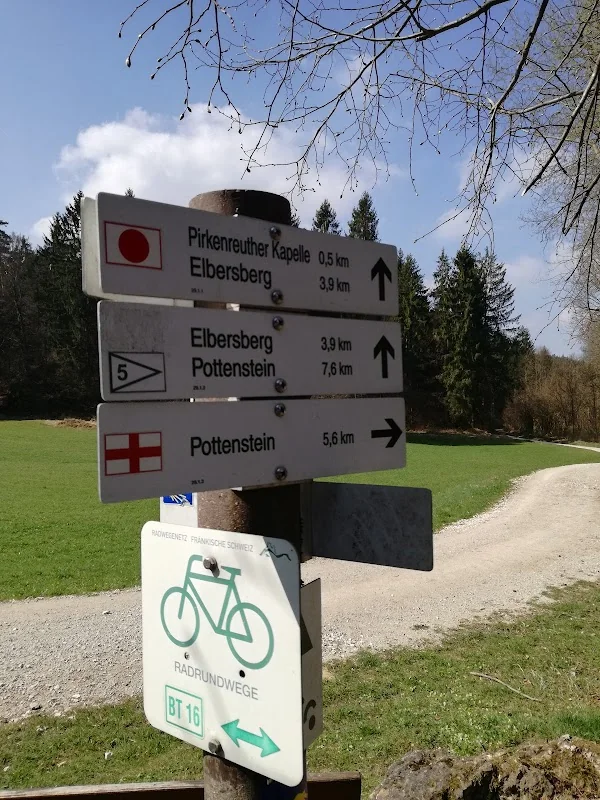
Hollenberg is also a real reference point for cyclists. The mountain bike tour from Pegnitz to Pottenstein starts at Zaußenmühle and initially leads to the Schloßberg festival meadow, then through a mixed forest into a first single trail to Hollenberg. Upon arrival, a short carrying phase begins before the route leads past the Dwarf Cave to the Ruins of Hollenberg; afterwards, it continues through narrow rock crevices, to the parking lot, and up to the dilapidated Pirkenreuther Chapel. Later, Hollenberg appears again when the route from the tour guide continues towards Körbeldorf and Kleiner Kulm. For SEO as well as for real visitors, this is an important point: Hollenberg is not just a name on the outskirts but a hub in the tourist network of the Franconian Switzerland. Those who hike or bike use the place as an intermediate destination, viewpoint, and orientation in the terrain. ([pegnitz.de](https://www.pegnitz.de/tourismus-freizeit/tourismus-freizeit/radfahren/mountainbike.html))
Access, Parking, and On-Site Access
Practical accessibility is essential for a small district like Hollenberg. According to available information, a municipal connecting road leads to Körbeldorf and from there to the district road BT 26, which is about 1.4 kilometers northeast. This makes it clear that Hollenberg is located in a rural area but is not isolated. At the same time, the documentation of the local walks shows that the internal development is not intended for heavy through traffic. There, a turning triangle between Hollenberg 1 and 3 is mentioned because there was no turning possibility for garbage collection, snow plowing, and school buses in the village. For visitors, this means: Hollenberg is a place that is better approached with some consideration and planning, especially if arriving by car or preparing a route. The character of the place remains pleasantly quiet, and this is an advantage for many guests. ([de.wikipedia.org](https://de.wikipedia.org/wiki/Hollenberg_%28Pegnitz%29))
For parking, the town of Pegnitz mentions a hiking parking lot east of the village. However, the same documentation also notes that there were too few parking spaces for hikers and that tourists did not always recognize the parking lot as a public parking area. These hints are very useful in practice because they show that one should not rely on spontaneous gaps at the roadside. Therefore, those who want to visit Hollenberg should specifically look for the official hiking parking lot, pay close attention to the signage, and especially arrive early in good weather. From an SEO perspective, such information is valuable because people searching for Hollenberg parking and Hollenberg access usually expect a direct answer. The most reliable answer here is: It is best to drive directly to the hiking parking lot east of the village and plan the place not as a transit station but as a starting point for hikes and short visits. ([pegnitz.de](https://www.pegnitz.de/_Resources/Persistent/e/8/3/8/e838ba9189e41032dd8be1277096cb69c66457d6/11-dokumentation-koerbeldorf_31-10-15.pdf))
Pirkenreuther Chapel and the Hollenberg Environment
Those who walk further from Hollenberg quickly encounter more exciting destinations. The official mountain bike description leads from the Ruins of Hollenberg to the dilapidated Pirkenreuther Chapel. The hiking route to Voitshöhle and the cultural monument Schmierstein also mentions the signage towards Ruins of Hollenberg, Dwarf Cave, and Gnome Spring. This makes it clear that Hollenberg is not just an individual place but an entry point into a whole complex of historical, geological, and landscape points. This connection is important for a long-term SEO text: People searching for Hollenberg are often interested not only in the hamlet itself but also in the next destinations that can be sensibly reached from there. In practice, this results in a short but content-rich excursion where history, nature, and movement come together in a small space. ([pegnitz.de](https://www.pegnitz.de/tourismus-freizeit/tourismus-freizeit/radfahren/mountainbike.html))
The larger Pegnitz area also supports this impression. The town describes itself as a place with high recreational value and short distances, and the official tours show how closely the destinations around Pegnitz are connected: Zaußenmühle, Pegnitz spring, Schloßberg, Hollenberg, Dwarf Cave, Pirkenreuther Chapel, and other ridges are connected in a network of hiking and biking trails. Hollenberg benefits from this because the place is enhanced by the landscape design without losing its quiet structure. For visitors, this is ideal: One can make a historical stop here, walk a piece of the castle rampart, enjoy the view of the surroundings, and then continue the tour. This combination of a quiet location and immediate path connection makes Hollenberg a location that appears small on maps but offers surprisingly much in experience. ([pegnitz.de](https://www.pegnitz.de/?utm_source=openai))
Hollenberg Today: A District with Peace and History
Today, Hollenberg is primarily a district with a strong identity in a small space. Since its incorporation into the town of Pegnitz on July 1, 1972, the hamlet has belonged administratively to the town but remains clearly distinguished from the core city in its appearance. Its location in the district of Körbeldorf, on the Schloßberg, and close to historical remnants gives the place a special character that is difficult to capture in short formulas. Those who enter the name Hollenberg into search engines often look for history, access, parking, hiking, or ruins; these topics are brought together here. For a visitor, this is sensible because the most important questions on-site actually revolve around access, orientation, and the historical environment. For this reason, Hollenberg functions both as a destination for a short detour and as a starting point for longer excursions into the Franconian Switzerland. ([de.wikipedia.org](https://de.wikipedia.org/wiki/Hollenberg_%28Pegnitz%29))
In summary, Hollenberg is a quiet but content-rich place in Pegnitz. The castle ruins tell of the time of Charles IV, the Dwarf Cave and the Schloßberg give the surroundings a distinctive topographical structure, and the hiking and mountain biking routes show how lively this history is still utilized today. Those who enjoy history, nature, and short distances will find a place here that does not need to be loud to make an impression. This is precisely its strength: Hollenberg is not a large event location but a landscape and historically shaped district that remains memorable due to its location, its paths, and its visible traces. ([historisches-unterfranken.uni-wuerzburg.de](https://www.historisches-unterfranken.uni-wuerzburg.de/burgen/burgen-einzeln.php?burg=778))
Sources:
Mehr anzeigenWeniger anzeigen
Hollenberg | Ruins of Hollenberg & Hiking
Hollenberg is a small, historically grown district of the town of Pegnitz in the district of Bayreuth. The hamlet is located in the district of Körbeldorf, on the Schloßberg, and thus in a landscape area that has long been associated with views, castle history, and recreational paths in Pegnitz. Visitors to Hollenberg do not encounter a classic village with much hustle and bustle, but rather a place that stands out mainly due to its location, its medieval traces, and its immediate access to nature and hiking trails. The listed monuments include a wayside cross, the Pirkenreuther Chapel, and the ruins of Hollenberg. This very mix makes Hollenberg interesting for guests seeking short distances, quiet perspectives, and genuine local history. ([de.wikipedia.org](https://de.wikipedia.org/wiki/Hollenberg_%28Pegnitz%29))
Ruins of Hollenberg and Medieval History
The history begins with the Hollenberg Castle, which was built after 1357 on the orders of Emperor Charles IV. The data from the Historical Lower Franconia Project mentions a steward for the first time in 1363; in the Neubohmian land register from 1366 to 1368, the site already appears as Holenperg. This shows that the name Hollenberg is not a modern invention, but part of a very old history of rule and settlement. For visitors, this is the exciting point, as the current hamlet is not isolated in the terrain, but located in a place where medieval administration, strategic elevation, and later village development overlap. The place name is interpreted in literature as a reference to the hollow mountain, i.e., to the topographical shape of the ridge on which the site was located. Therefore, to understand Hollenberg, one should not only think of the ruins but also of the long line between castle, place, and landscape that remains visible to this day. ([historisches-unterfranken.uni-wuerzburg.de](https://www.historisches-unterfranken.uni-wuerzburg.de/burgen/burgen-einzeln.php?burg=778))
The later stages of this history are also remarkable. In 1397, the castle was first pawned to the Landgrave of Leuchtenberg. Around 1400, after the deposition of Wenceslaus as Roman King, it came to the Palatinate side, changed hands multiple times, and was also damaged during this phase. In 1410, it fell to Johann of Palatinate-Neumarkt, in 1465 the ownership question was decided in favor of Otto of Palatinate-Mosbach, and in 1525 a site, presumably destroyed in the Peasants' War, is mentioned, which was not rebuilt afterwards. For the present place, this means: Hollenberg does not only live from a single monument but from a whole chain of political and territorial changes that can be read in the history of the castle. This context is particularly valuable for history enthusiasts because it shows that the inconspicuous hamlet is located at a point where power history and landscape history directly intersect. ([historisches-unterfranken.uni-wuerzburg.de](https://www.historisches-unterfranken.uni-wuerzburg.de/burgen/burgen-einzeln.php?burg=778))
Dwarf Cave, Schloßberg, and Views
Topographically, Hollenberg is closely connected to the Schloßberg. The Wikipedia description locates the hamlet at the Schloßberg and explicitly mentions the Dwarf Cave; furthermore, a municipal connecting road leads from Hollenberg to Körbeldorf to the district road BT 26. For visitors, this means: Hollenberg is not difficult to reach, but is still located in a quiet landscape. This location is the reason why the place keeps appearing in Pegnitz's recreational paths. It marks a transition between settlement and forest, between the edge of the village and the ridge, between everyday paths and excursion destinations. Those who move from the village to the mountain experience the special proximity of village, rock formations, and historical terrain. Thus, Hollenberg is less a place to pass through than a place to consciously arrive. The surroundings appear compact, yet open enough to connect history, nature, and views in a short distance. ([de.wikipedia.org](https://www.de.wikipedia.org/wiki/Hollenberg_%28Pegnitz%29))
The Schloßberg itself is a defining point for Pegnitz. The town describes it as a landmark, mentions a height of 544 meters, and refers to 97 steps to the observation tower, a wide panoramic view, the festival meadow, the children's festival Gregori, and the beer garden. Although these details concern the Schloßberg as a destination in its own right, they indirectly shape Hollenberg because the hamlet is spatially and touristically embedded in this elevated area. Those who are in Hollenberg experience not only an individual hamlet but a part of the Pegnitz highland landscape, where castle remnants, views, and recreational use intertwine. This also explains why Hollenberg is as interesting for short detours as it is for longer tours: The place is exactly where the quieter topography of the Schloßberg meets the tourist routes of the town. ([pegnitz.de](https://www.pegnitz.de/tourismus-freizeit/sehenswuerdigkeiten/schlossberg.html))
Hiking and Mountain Biking around Hollenberg
Hollenberg plays a clear role in the official recreational offerings of the town of Pegnitz. The hiking route to Voitshöhle and the cultural monument Schmierstein leads from the community center over the northern side of the Schloßberg, past Zaußenmühle and the Pegnitz spring, further towards Körbeldorf and finally to Hollenberg. There, the path is explicitly marked with Ruins of Hollenberg, Dwarf Cave, and Gnome Spring. This is particularly valuable for guests because the route does not just aim for a single destination but integrates Hollenberg into a coherent network of paths. The official description also mentions old beech stands, dry valleys, and the castle rampart, making it clear that this is not about an arbitrary walk but about a landscape and historically charged route. Those who reach Hollenberg via this tour experience the place as part of a larger movement through the Pegnitz heights, not as an isolated point on the map. ([pegnitz.de](https://www.pegnitz.de/tourismus-freizeit/tourismus-freizeit/wandern/tor-zur-voitshoehle-und-zum-kulturdenkmal-schmierstein.html))
Hollenberg is also a real reference point for cyclists. The mountain bike tour from Pegnitz to Pottenstein starts at Zaußenmühle and initially leads to the Schloßberg festival meadow, then through a mixed forest into a first single trail to Hollenberg. Upon arrival, a short carrying phase begins before the route leads past the Dwarf Cave to the Ruins of Hollenberg; afterwards, it continues through narrow rock crevices, to the parking lot, and up to the dilapidated Pirkenreuther Chapel. Later, Hollenberg appears again when the route from the tour guide continues towards Körbeldorf and Kleiner Kulm. For SEO as well as for real visitors, this is an important point: Hollenberg is not just a name on the outskirts but a hub in the tourist network of the Franconian Switzerland. Those who hike or bike use the place as an intermediate destination, viewpoint, and orientation in the terrain. ([pegnitz.de](https://www.pegnitz.de/tourismus-freizeit/tourismus-freizeit/radfahren/mountainbike.html))
Access, Parking, and On-Site Access
Practical accessibility is essential for a small district like Hollenberg. According to available information, a municipal connecting road leads to Körbeldorf and from there to the district road BT 26, which is about 1.4 kilometers northeast. This makes it clear that Hollenberg is located in a rural area but is not isolated. At the same time, the documentation of the local walks shows that the internal development is not intended for heavy through traffic. There, a turning triangle between Hollenberg 1 and 3 is mentioned because there was no turning possibility for garbage collection, snow plowing, and school buses in the village. For visitors, this means: Hollenberg is a place that is better approached with some consideration and planning, especially if arriving by car or preparing a route. The character of the place remains pleasantly quiet, and this is an advantage for many guests. ([de.wikipedia.org](https://de.wikipedia.org/wiki/Hollenberg_%28Pegnitz%29))
For parking, the town of Pegnitz mentions a hiking parking lot east of the village. However, the same documentation also notes that there were too few parking spaces for hikers and that tourists did not always recognize the parking lot as a public parking area. These hints are very useful in practice because they show that one should not rely on spontaneous gaps at the roadside. Therefore, those who want to visit Hollenberg should specifically look for the official hiking parking lot, pay close attention to the signage, and especially arrive early in good weather. From an SEO perspective, such information is valuable because people searching for Hollenberg parking and Hollenberg access usually expect a direct answer. The most reliable answer here is: It is best to drive directly to the hiking parking lot east of the village and plan the place not as a transit station but as a starting point for hikes and short visits. ([pegnitz.de](https://www.pegnitz.de/_Resources/Persistent/e/8/3/8/e838ba9189e41032dd8be1277096cb69c66457d6/11-dokumentation-koerbeldorf_31-10-15.pdf))
Pirkenreuther Chapel and the Hollenberg Environment
Those who walk further from Hollenberg quickly encounter more exciting destinations. The official mountain bike description leads from the Ruins of Hollenberg to the dilapidated Pirkenreuther Chapel. The hiking route to Voitshöhle and the cultural monument Schmierstein also mentions the signage towards Ruins of Hollenberg, Dwarf Cave, and Gnome Spring. This makes it clear that Hollenberg is not just an individual place but an entry point into a whole complex of historical, geological, and landscape points. This connection is important for a long-term SEO text: People searching for Hollenberg are often interested not only in the hamlet itself but also in the next destinations that can be sensibly reached from there. In practice, this results in a short but content-rich excursion where history, nature, and movement come together in a small space. ([pegnitz.de](https://www.pegnitz.de/tourismus-freizeit/tourismus-freizeit/radfahren/mountainbike.html))
The larger Pegnitz area also supports this impression. The town describes itself as a place with high recreational value and short distances, and the official tours show how closely the destinations around Pegnitz are connected: Zaußenmühle, Pegnitz spring, Schloßberg, Hollenberg, Dwarf Cave, Pirkenreuther Chapel, and other ridges are connected in a network of hiking and biking trails. Hollenberg benefits from this because the place is enhanced by the landscape design without losing its quiet structure. For visitors, this is ideal: One can make a historical stop here, walk a piece of the castle rampart, enjoy the view of the surroundings, and then continue the tour. This combination of a quiet location and immediate path connection makes Hollenberg a location that appears small on maps but offers surprisingly much in experience. ([pegnitz.de](https://www.pegnitz.de/?utm_source=openai))
Hollenberg Today: A District with Peace and History
Today, Hollenberg is primarily a district with a strong identity in a small space. Since its incorporation into the town of Pegnitz on July 1, 1972, the hamlet has belonged administratively to the town but remains clearly distinguished from the core city in its appearance. Its location in the district of Körbeldorf, on the Schloßberg, and close to historical remnants gives the place a special character that is difficult to capture in short formulas. Those who enter the name Hollenberg into search engines often look for history, access, parking, hiking, or ruins; these topics are brought together here. For a visitor, this is sensible because the most important questions on-site actually revolve around access, orientation, and the historical environment. For this reason, Hollenberg functions both as a destination for a short detour and as a starting point for longer excursions into the Franconian Switzerland. ([de.wikipedia.org](https://de.wikipedia.org/wiki/Hollenberg_%28Pegnitz%29))
In summary, Hollenberg is a quiet but content-rich place in Pegnitz. The castle ruins tell of the time of Charles IV, the Dwarf Cave and the Schloßberg give the surroundings a distinctive topographical structure, and the hiking and mountain biking routes show how lively this history is still utilized today. Those who enjoy history, nature, and short distances will find a place here that does not need to be loud to make an impression. This is precisely its strength: Hollenberg is not a large event location but a landscape and historically shaped district that remains memorable due to its location, its paths, and its visible traces. ([historisches-unterfranken.uni-wuerzburg.de](https://www.historisches-unterfranken.uni-wuerzburg.de/burgen/burgen-einzeln.php?burg=778))
Sources:
Upcoming Events
No events found
Frequently Asked Questions
Reviews
No reviews found